How Mine Drones Are Improving Safety and Optimizing Mining
6 Ways Mine Drones Are Being Used
Mine drones have become essential tools in both underground and surface mining operations. As drone technology continues to evolve rapidly, the potential for integrating these devices into mining processes is expanding endlessly.
What Is a Mine Drone?
A mine drone is specifically designed or adapted for mining applications such as stockpile measurement, surveying, mapping, and inspections, including ultrasonic thickness testing. Mining is inherently dangerous, with unpredictable working conditions that can change at any moment. Both underground and surface mining present unique challenges and risks.
While mine drones won't eliminate all dangers, they can collect data from areas where humans cannot go. A key difference between mine drones and consumer drones is their ability to operate without GPS, which is often unavailable in mining environments.
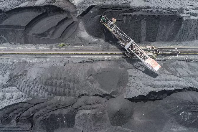 Aerial drone footage of a surface coal mine
The mining industry has quickly adopted drone technology due to its ability to improve data collection, enhance safety, and reduce operational costs. Here are six ways drones are being used in mining:
1. Volumetric Monitoring
Volumetric measurement involves calculating how much material remains in stockpiles of overburden, ore, or other mining materials. Due to the large size of these stockpiles, manual methods are inefficient and inaccurate.
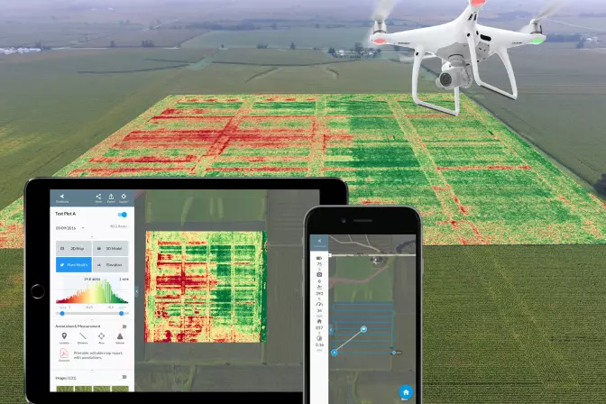
Drones allow for quick and cost-effective volume data collection. Using advanced software, drone data can be processed into 3D models that track changes over time. These models help in estimating backfill needs and monitoring excavation progress.
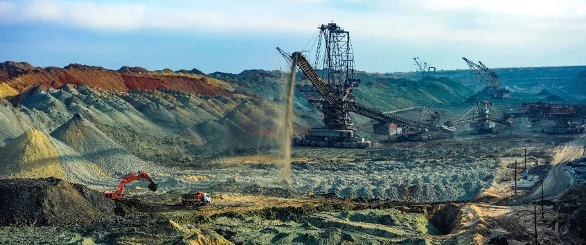 Processing overburden into stockpiles
2. Identifying Hazards
Cracked rocks, gas leaks, dust explosions, and hazardous underground conditions pose significant risks. By using UAVs, surveyors can reduce these risks by removing people from dangerous inspection tasks.
In surface mining, drones monitor stockpile stability, while in underground mines, they navigate dusty and rocky areas to detect blockages and create 3D models of geological features.
3. Drilling and Blasting Assessment
Drones generate 3D models that help analyze the impact of drilling and blasting. These models support future decision-making, assess blasting effectiveness, and provide remote safety checks before human entry.
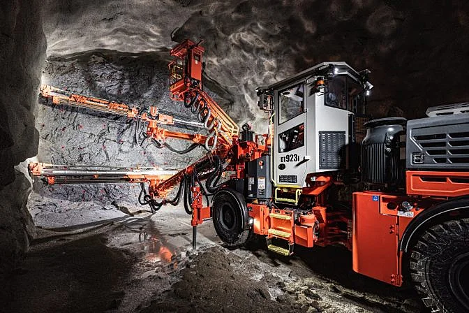 Drilling holes for explosives
4. Mine Monitoring and Planning
Drones play a crucial role in haulage road design, equipment inspection, worksite security, and environmental monitoring. They help maintain infrastructure, ensure safety, and protect the environment by monitoring tailings dams and other critical systems.
5. Mine Development and Exploration
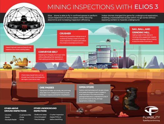
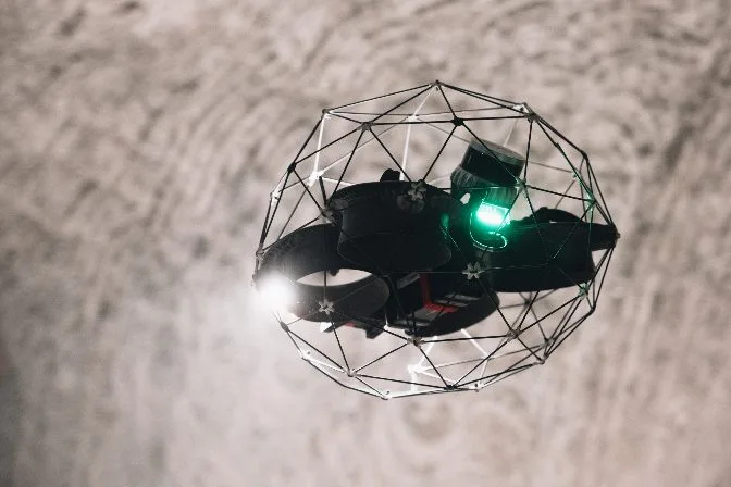
Drones are invaluable for exploring inaccessible areas, reducing risks for miners, and collecting critical data. The Elios 3 is particularly suited for confined underground spaces with poor visibility and air quality.
6. Processing Plant Inspections
Drones inspect processing plant machinery without disrupting operations. They check wear and tear, measure thickness, and monitor temperatures, ensuring efficient and safe production.
The Benefits of Drones in Mining
As drone technology advances, the benefits of using UAVs in mining continue to grow. Drones improve safety, reduce costs, and optimize efficiency through aerial data collection, frequent inspections, and remote monitoring.
Some key advantages include faster data gathering, reduced human risk, improved accuracy, and enhanced environmental protection. Drones like the Elios 3 offer unmatched performance in challenging mining environments.
Watch the Elios inspect and map an obstructed ore pass:
Â
The Best Indoor Mine Drone on the Market
Flyability’s Elios 3 stands out for its durability, functionality, and beyond-line-of-sight transmission. Its collision-tolerant design allows it to navigate dark, dusty, and dangerous environments safely. Equipped with a dual thermal and 4K camera, along with high-intensity lighting, the Elios 3 captures detailed visual data for thorough inspections.
With easy maintenance, training, and dedicated support, the Elios 3 is a top choice for indoor mining applications.
Flyability Elios 3 Specs / Features:
- Dual Thermal/Camera Sensor: 12 megapixels HD live streaming
- Lighting: 10k Lumen dust proof lighting with oblique lighting
- LiDAR mapping: Real-time 3D view of the drone’s trajectory and environment. Scanner captures 1 million point per second with centimeter accuracy.
- Flight Time: 10 minutes
- Flight Speed: 6.5 m/s
- Transmission System: Beyond visual line-of-sight
- Modular payloads: Use highly specialized LiDAR sensor and ultrasonic thickness payload to enhance the quality and type of data gathered during an inspection
 Elios 3
Best Fixed Wing Outdoor Mine Drones on the Market
WingtraOne GEN II
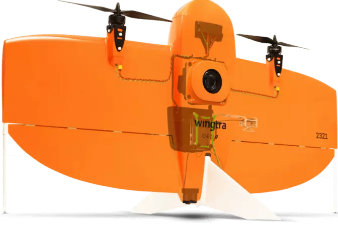
The WingtraOne GEN II offers extended flight time, speed, and flexibility. With a 42-megapixel camera, it can cover up to 272 acres in one flight. Its vertical takeoff and landing (VTOL) system makes it ideal for remote and challenging locations.
WingtraONE GEN II Specs / Features:
-
Camera Sensor: 42 megapixel Sony sensor with full-frame and low distortion lens.
-
Sensing Capabilities: Compatible with various Sony and MicaSense sensors.
-
Flight Time: 59 minutes
-
Flight Speed: 16 m/s (36 mph)
-
Transmission System: Direct line-of-sight up to 10 km (6 miles).
 WingtraOne Gen II
SenseFly eBeeX
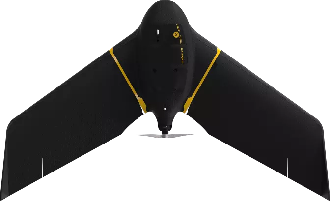
The eBeeX is a fully autonomous drone capable of covering 1200 acres per flight. It supports multiple cameras and is compatible with various sensors, making it versatile for different mining tasks.
SenseFly eBeeX Specs / Features:
-
Camera Sensor: Choose from 9 sensors, including aerial RGB, thermal, and multispectral imagery.
-
Sensing Capabilities: Compatible with various SenseFly and MicaSense sensors.
-
Flight Time: 90 minutes
-
Flight Speed: 30 m/s (68 mph)
-
Transmission System: Flight range of 37 km (23 miles).
 SenseFly eBeeX
Best Multicopter Outdoor Mine Drone on the Market
DJI Phantom 4 RTK
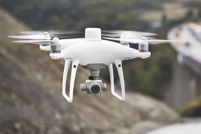
The DJI Phantom 4 RTK is a top choice for outdoor mining due to its 20-megapixel CMOS sensor, accurate mapping capabilities, and long-range transmission. It's ideal for medium-sized mine sites.
DJI Phantom 4 RTK Specs / Features:
-
Camera Sensor: 20 megapixels with 4K video resolution.
-
Flight Time: 30 minutes
-
Flight Speed: 13 m/s (31 mph) in P-Mode / 16 m/s (36 mph) in A-Mode.
-
Transmission System: DJI OcuSync.
DJI Phantom 4 RTK
Best Mine Drone Software
DroneDeploy
DroneDeploy enhances mining operations with tools for stockpile management, mine planning, and safety. It helps teams make data-driven decisions and improves overall efficiency.
Top Features:
-
Stockpile Inventory Management
-
Mine Planning and Excavation
-
Safety and Compliance
-
Centralized Operations Management
 DroneDeploy software | Medium
Pix4D
Pix4D provides advanced 3D modeling and geotechnical hazard forecasting, helping to minimize risks and improve profitability in mining operations.
Top Features:
-
Forecast geotechnical hazards
-
Accurate and automatic stockpile volume calculation
-
Asset lifecycle management
-
Generate high-resolution interactive 3D maps
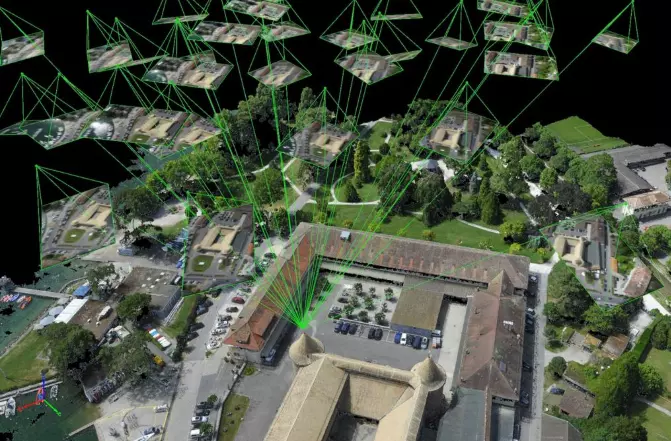 Pix4D software
Propeller
Propeller’s software enables fast and accurate 3D modeling, improving project documentation and team collaboration across all stages of mining operations.
Top Features:
-
Quick and frequent drone surveys
-
Complete documentation of project lifecycle
-
Simplified inventory management
-
Collaboration and communication
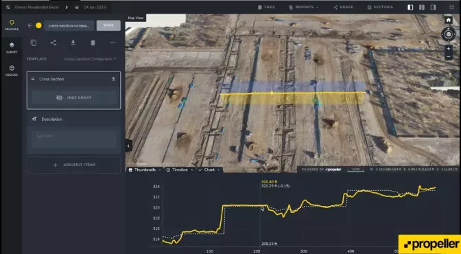 Propeller software
Skycatch
Skycatch offers automation, data processing, and analysis tools for aerial data capture. It also includes onboarding and ongoing support for seamless integration into mining workflows.
Top Features:
-
Fastest time-to-data in the market
-
Eliminates GCPs for safer data capture
-
Proven 5 cm accuracy across all axes
-
Process offline in the field or in the cloud
-
Precise, high-fidelity 3D models of vertical surfaces
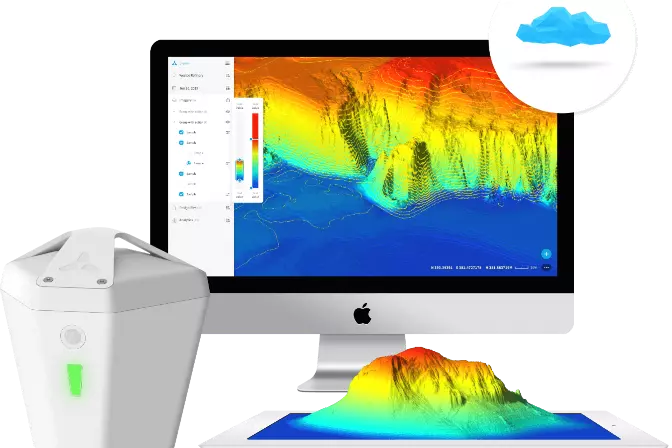
Skycatch software
Mining Drone Case Studies
Flyability Elios 2 — Inspection
Application: High-Altitude Underground Mining Inspection
Mission: Demonstrate the ability of the Elios 2 to cut down costs and improve safety in a high-altitude oxygen-depleted mine environment.
Results: The Volcan team conducted 40 flights with the Elios 2 inspecting chimneys, ore passes, ventilation tunnels, and stopes. 3D maps of the various flights were created using Pix4D mapping software. All planned inspections were a success, and the drone met all expectations.
Mine Drone Significance: The Elios 2 was able to operate where no other drone could. Many mines are located in high-altitude locations where regular drone use is not feasible. By using a drone to navigate the mine, miners can let the Elios 2 do the dirty work while saving time and money.
[Read the full case study here: Testing the Elios 2 at a High Altitude Mine Located in the Andes Mountains]
Wingtra— Survey
Application: Mine / Quarry Monitoring and Operational Planning
Mission: Reduce operating expenses of terrestrial and manned airplane surveys by integrating a fixed-wing mine drone platform into surveying operations.
Results: The Jellinbah Group found that utilizing the WingtraOne drone resulted in a significant decline in operational expenses and time. The fixed-wing platform also alleviated the inefficiencies of quadcopters that the company had tested previously. The ROI is immediately noticed as Jellinbah can now conduct on-demand surveys compared to the time-consuming logistics of manned surveying.
Mine Drone Significance: Large mining sites are no longer limited to multirotor drones that are inefficient and impractical. The vertical takeoff and landing feature is also a game-changer and allows surveys to be conducted anywhere.
SenseFly— Survey
Application: Quarry Monitoring and Operational Planning
Mission: Survey the largest limestone quarry in a day. The quarry measures a whopping 13.7 km², and it usually takes two months to survey.
Results: The quarry was split into three large segments; upper, middle, and lower. Four drone pilots were divided into two teams to cover the site efficiently. The team decided to use senseFly's eBeeX fixed-wing drone. The eBeeX's ability to fly for longer durations made it the perfect choice. Within a few hours, the drone took over 6,000 high-resolution images that were converted into orthomosaic images and 3D models.
Mine Drone Significance: Surveying a site of this size used to take up to 2 months. Not only does that cause delays, but it also increases the risks for surveyors. The benefit of using mine drones is quick turnaround time, resulting in a safer and more cost-effective operation.
DJI— Survey
Application: Quarry Drilling and Blasting
Mission: To identify how a customized drone solution for mining can deliver the safest, controlled, and cost-efficient execution of a scheduled blast operation in a quarry mine.
Results: The customized DJI Matrice 300 RTK drone and Zenmuse H20t cameras functioned well regarding control and operational decision-making.
Here are some areas the drone excelled in:
-
Checking for compliance with minimum withdrawal distances
-
Correcting the locations of lookouts.
-
Replacement of the inspection vehicle bypass
-
Observation of blind spots
-
Overall survey and recording of mass explosion
Mine Drone Significance: The purpose of using drones in mining is to mix the miners' knowledge with the drone's digital intelligence. An operation becomes safer and less expensive to run overtime by having actionable data.
DroneDeploy— Stockpile Measurement
Application: Stockpile Volumetry
Mission: Improve the accuracy of volumetric stockpile measurements to increase safety and reduce expenses for Granite Construction.
Results: Using DroneDeploy, the company achieved accuracy comparable to traditional methods in a fraction of the time. For this site, all volume calculations were within 1% of alternatives.
Mine Drone Significance: Using aerial volumetric software is faster, safer, and half the cost of the traditional ground-based stockpile calculations.
Sporting series included Inflatable boat, canoe and kayak, Inflatable River Tubes, inflatable pool float, towable tubes, inflatable snow tubes and sheld.
· PD Toys plastic Co., Ltd is OEM & ODM manufacturer of inflatable products in the mainland of China with more 17 years of manufacturing experience.
· Operated under ISO 9001:2015 management system, We had passed factory Audit by Walmart, Taret, Disney ect, also passed all necessary certificates and testing such as ICTI, BSCI, SEMTA,Target FA, NBC Universal, FCCA, SGS, CVS Security, GSV, Disney FAMA ect.
· We have our own PVC raw materials manufacturing company, all the PVC we produced are compliance with European EN71, American ASTM standard and NON PHTHALATE (6P) standard.
Inflatable Camping Mat, Inflatable boat, Inflatable kayak canoe, Towable Tube, Inflatable Island, Inflatable Punching Bags
Lixin Outdoor Product Co., Ltd , https://www.pdinflatable.com