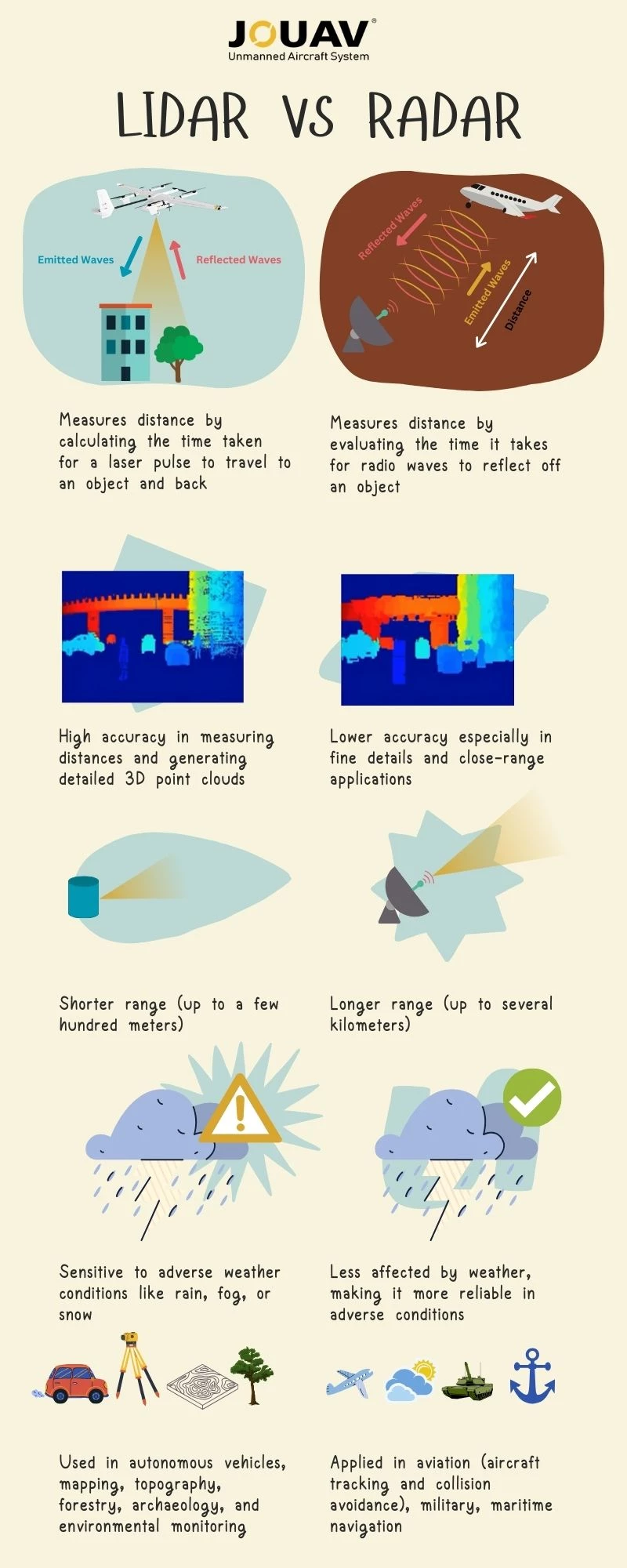
LiDAR vs. Radar: What's the Difference?
What Does LiDAR Stand for?
LiDAR, short for "Light Detection and Ranging," is a remote sensing technology that relies on laser light to measure distances accurately. This process enables the creation of highly detailed 3D maps of the environment. LiDAR systems operate by emitting rapid laser pulses and meticulously measuring the time it takes for the reflected light to return.
This technology has evolved significantly since its inception in the early 1960s, driven by advancements in lasers, computing, and data processing capabilities.
How Does LiDAR Work?
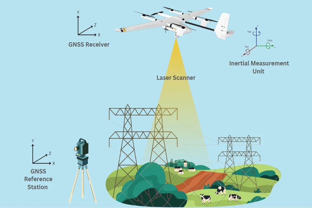
A typical LiDAR system consists of three essential components:
- Laser Source: LiDAR systems depend on lasers to emit rapid bursts of light, typically in the near-infrared spectrum. These laser pulses traverse the atmosphere until they encounter objects like terrain features, trees, or structures.
- Scanner: To ensure thorough data collection, a scanner, often a rotating mirror or micro-electromechanical system (MEMS), directs the laser pulses in various directions.
- Detector: The detector, an incredibly sensitive instrument, gauges the time it takes for the laser pulses to travel to objects and return to the LiDAR system. This "time-of-flight" principle, combined with the constant speed of light, allows for precise distance calculations.
When a laser pulse hits an object, such as a tree or a structure, the light bounces back to the LiDAR system. The scanner, often a revolving mirror or MEMS, collects and directs the returning light to the detector. The detector is a susceptible instrument that detects the time taken for light to travel back and forth between the LiDAR system and the object. This time-of-flight principle, combined with the constant speed of light, allows LiDAR to calculate the distance to an object accurately.
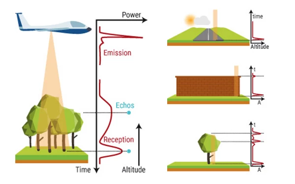
How does LiDAR work? Source from Yellowscan
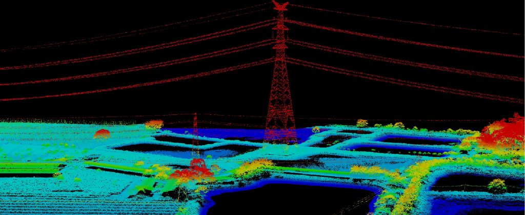
LiDAR devices release thousands or even millions of pulses per second to create a thorough map of the environment. This generates a massive amount of data, which is then utilized to generate a very accurate and detailed 3D map of the surroundings. The map's resolution is determined by the number of pulses emitted, the frequency of the laser, and the detector's sensitivity.
Topographic LiDAR
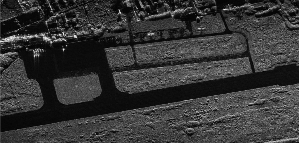
Topographic LiDAR is employed to derive surface models for many applications, including forestry, hydrology, geomorphology, urban planning, landscape ecology, coastal engineering, survey assessments, and volumetric calculations. It aids in creating precise representations of terrestrial landscapes and is invaluable for decision-making in various industries.
Bathymetric LiDAR
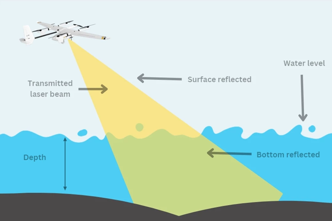
Bathymetric LiDAR is designed for water-penetrating acquisitions, collecting elevation and water depth data simultaneously. This sensor is particularly crucial for surveys of the land-water interface, especially near coastlines, harbors, shores, and banks. It facilitates the detection of objects on the ocean floor, serving marine and coastal applications effectively.
Mobile LiDAR
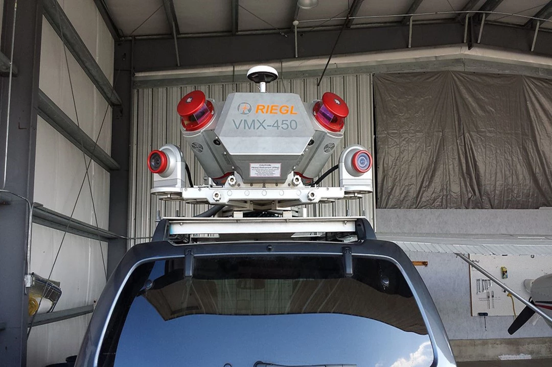
Mobile LiDAR systems are mounted on moving platforms, including vehicles, trains, and boats. With LiDAR sensors, cameras, GPS (Global Positioning System), and INS (Inertial Navigation System), mobile LiDAR is extensively used for infrastructure analysis, overhead wire detection, light pole identification, and sign assessment along roadways and rail lines. It finds wide-ranging applications in urban planning, transportation engineering, and infrastructure management.
Static LiDAR
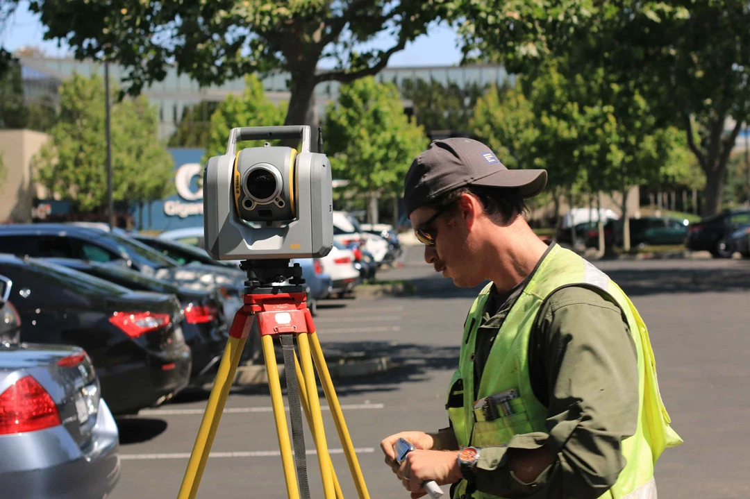
Static LiDAR sensors are deployed from a fixed location, typically mounted on a tripod or stationary device. These portable laser-based ranging and imaging systems are employed for an extensive array of applications. Engineers use static LiDAR to monitor facilities, conduct highway and rail surveys, and create detailed 3D models of urban exteriors and interiors. It is also indispensable for archaeological investigations, surveying, mining operations, and architectural planning.
What is Radar?
Radar, which stands for "Radio Detection and Ranging," is a formidable sensing technology that relies on radio waves to detect objects and measure their distances, velocities, and various characteristics.
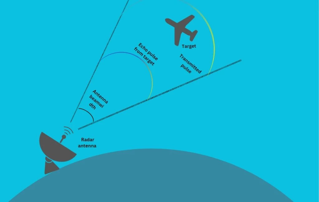
The essence of Radar lies in its ability to emit radio waves into the atmosphere, which then bounce back when they encounter an object. By analyzing the time taken for these radio waves to return and factoring in the frequency shift caused by the Doppler effect, Radar systems can accurately determine an object's distance, speed, and direction.
Radar has a rich history, dating back to its early development in the 20th century. Since then, this technology has undergone continuous refinement and improvement, earning its place in various industries, including aviation, meteorology, and military surveillance.
How Does Radar Work?
A typical Radar system consists of several key components, including:
- Antenna: The antenna is the part of the Radar that transmits and receives radio waves. It emits a radio signal and then captures the reflected waves.
- Transmitter: The transmitter generates the radio frequency signal, which is sent out by the antenna. The emitted radio waves travel through the air until they encounter an object.
- Receiver: The receiver is responsible for capturing the reflected radio waves after they bounce off an object. By analyzing the time it takes for the waves to return and their frequency shift (Doppler effect), Radar can calculate the distance, speed, and other characteristics of the detected object.
- Signal Processor: Radar data is processed to create a visual representation or provide information about the detected objects. Signal processing is crucial for extracting valuable information from the returned radio waves.
The electromagnetic energy used in radar travels through the air at a constant speed, approximately the speed of light (300,000 kilometers per second or 186,000 miles per second). By measuring the time between transmitting and receiving energy pulses, radar systems precisely determine the distance between the reflecting object - whether airplanes, ships, or cars - and the radar site.
Radar performance can be influenced by factors such as operating frequency, atmospheric conditions, and interference from electronic devices and obstacles. The radar's choice of frequency affects its ability to penetrate materials and its susceptibility to signal interference. Atmospheric conditions, like precipitation, can reduce radar accuracy and range.
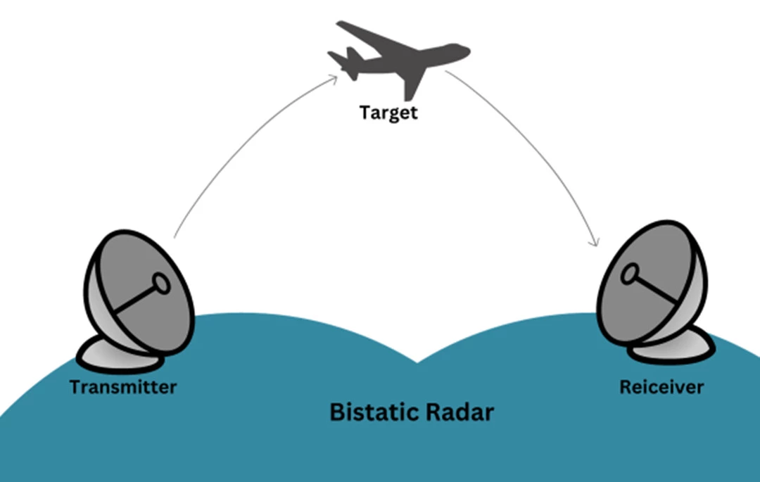
Bistatic Radar
Bistatic Radar systems consist of a static transmitter and a static receiver, positioned at a significant distance from each other, roughly matching the expected target distance. These systems excel when the target reflects minimal energy toward the receiver, such as in modern stealth technology-equipped fighter jets or in meteorological applications.
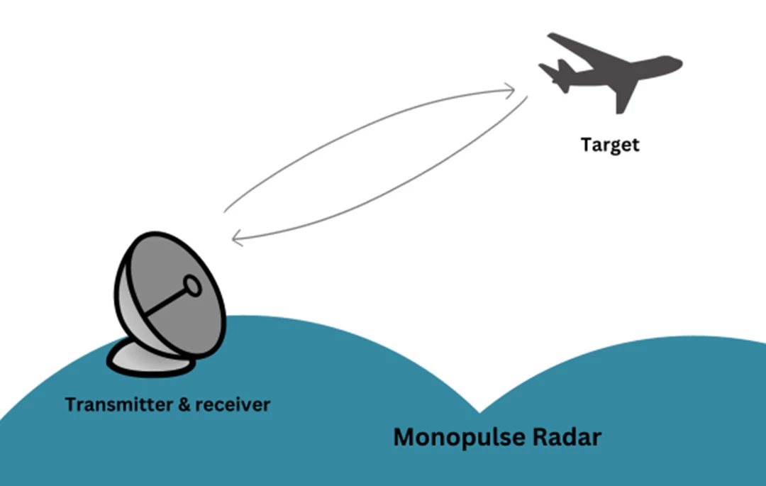
Monopulse Radar
Monopulse Radar employs single, narrow pulses of electromagnetic energy to accurately gauge an object's distance and direction. It sends out energy signals that split into two beams extending to each side of the intended target. Analyzing the difference between the two reflected signals determines the precise direction of the object. Monopulse Radar systems are advanced and widely used in high-accuracy military applications.
Cemented Carbide Cutting Tools,Tungsten Carbide Cutting Tools,Cemented Carbide Blade,Carbide Tools
Zigong Yibaijie , https://www.oz-yibaijie.com